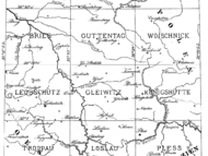
Geognostische Karte von Oberschlesien und den angrenzenden Gebieten, 1868
tags: roemer, oppeln, polen, schlesien, geologische karten| Blatt/Section | Höchstauflösung |
|---|---|
| 1. Section Namslau | ULB Münster: 2875682, DBC Wrocław: 12028 |
| 2. Section Creutzburg | ULB Münster: 2875673, DBC Wrocław: 12029 |
| [3]. [Titel und Legende] | ULB Münster: 2875691 |
| 4. Section Brieg | ULB Münster: 2875664, DBC Wrocław: 12030 |
| 5. Section Guttentag | ULB Münster: 2875655, DBC Wrocław: 12031 |
| 6. Section Woischnick | ULB Münster: 2875646, DBC Wrocław: 12032 |
| 7. Section Leobschütz | ULB Münster: 2875637, DBC Wrocław: 12033 |
| 8. Section Gleiwitz | ULB Münster: 2875628, DBC Wrocław: 12034 |
| 9. Section Königshütte | ULB Münster: 2875620, DBC Wrocław: 12035 |
| 10. Section Troppau | ULB Münster: 2875610, DBC Wrocław: 12037 |
| 11. Section Loslau | ULB Münster: 2875602, DBC Wrocław: 12038 |
| 12. Section Pless | ULB Münster: 2907523, DBC Wrocław: 12040 |
| Erläuterungen | Sektion: Gleiwitz, Königshütte, Loslau und Pless |
Quellen:
- DBC Wrocław (.PDF, .TIF), Digitalisate frei nutzbar (CC PD 1.0)
- ULB Münster = urn:nbn:de:hbz:6:1-126516 (nur .JPG), Digitalisate nicht frei verwendbar

Beim Nutzen des Hilfsdienst https://xyz2bbox.kreidefossilien.de bin ich auf das Problem gestoßen,… vor 10 Monaten
Blatt 42 (4840) Borna ist leider nicht korrekt verlinkt. vor 1 Jahr, 1 Monat
Der Kockelsbergtunnel wird südlich wieder in die Strecke Berlin-Dresden einbinden, nicht auf… vor 2 Jahren, 3 Monaten
Sehr schöne Anleitung, danke! vor 3 Jahren, 2 Monaten
Digitalisat von Tafel II aus Schulze, 1770 in guter Qualität hinzugefügt. Quelle: https://books.google.de/books?id=nHJlAAAAcAAJ&pg=PA37 vor 4 Jahren